|
|
by Gary Lee Phillips
The following description applies to public domain lands that were surveyed by the United States after the Act of 18 May 1796, which set standard methods for all such surveys. These methods were followed in almost all the public land states, with the notable exception of Ohio where various other methods had already been used in various parts of the state.
For Michigan, the only lands not included in this system are those that were allocated by prior claims recognized by the US at the time it took jurisdiction. Most of those were instituted under French or British authority, and were laid out according to the prevailing methods of those nations, using either the old "metes and bounds" survey and land description or the French custom of making "long lots" (narrow plots of land along the banks of rivers or lakes, each of which had access to the water.) These older claims are primarily found along the Detroit and St. Clair Rivers and the shores of Lake St. Clair, and near other French settlements such as Sault Ste. Marie and Marquette.
Also known as Congressional townships, these were the basic units that government surveyors used to lay out land descriptions in the public domain states. Each township is, in theory, a square six miles on a side, containing 23,040 acres of land. In many cases, these survey townships eventually were organized as units of local government. County boundaries were often determined by constituting a county to include a certain group of townships.
Townships were identified on the survey by the range system, a cartesian coordinate grid. For each survey area (whether part of a state, a whole state, or multiple states) a set of axes had to be chosen. The east/west axis, or base line, followed a parallel of latitude, and townships were numbered north and south of this line: township 1 north, township 2 north, township 3 north, etc. The north/south axis, or principal meridian, was a meridian of longitude, and townships were numbered in ranges (columns) east or west of that line: range 1 west, range 2 west, range 3 west, etc.
The following diagram shows schematically the arrangement of townships around the origin, or intersection, of a base line and principal meridian.
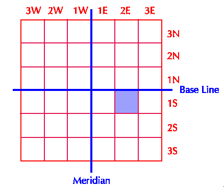
In this figure, the entire diagram is 36 miles on a side. Each smaller square represents one township. The shaded township is used in the remaining examples in this explanation, and would be designated as Township one south range two east of the principal meridian or, more briefly, as T1SR2E.
Since actual meridians of longitude are not truly parallel (they converge at the earth's poles) some adjustments had to be made at intervals so not all townships are perfectly square. In some areas, errors in the early survey work have resulted in even more significant deviations. In places where surveys based on different axes met each other, the deviation can be quite large. You can see a good example of this if you look at township boundaries where Michigan's upper penninsula meets Wisconsin.
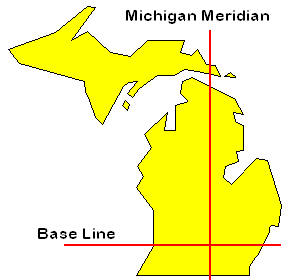
In spite of its imperfections, however, this system is still used to survey and describe units of land in most states west of the Appalachian mountains, and prevails throughout Michigan. The base line for Michigan forms the boundary between Oakland and Wayne Counties. The principal meridian runs east of Lansing, and forms the boundary between Clinton and Shiawassee Counties.
Sections
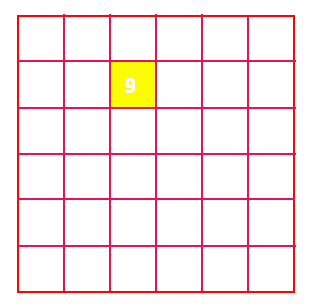
Each township was further subdivided into 36 sections, each of which is a square of land one mile on a side and equivalent to 640 acres. Sections were numbered within the township starting at the northeast corner and working first from east to west, then west to east in alternating rows, as shown in the next diagram. This diagram represents T1SR2E, the township selected in the previous map. The area shown is one mile on a side, and the shaded section (section nine) is used in the examples that follow later.
Townships that did not contain a complete complement of 36 sections (whether due to irregularities caused by bodies of water or other obstacles, or because they stood at the meeting points between two different surveys) were divided in the same manner, and whatever sections did exist were numbered as they would have been numbered had the township been complete. For example, if the northeast corner of a township were cut off by a lake so that section 1 would lie entirely in the lake, then that section does not exist, but numbering for the remaining sections begins with 2 in the next section to the west. There could also be partial sections, containing less than a full 640 acres, for the same reasons.
Land Descriptions and Allocations
In most cases, actual land units were created by dividing sections into quarters, and quartering those units again (and sometimes a third time.) The equivalent land area in acres is given by the following table:
| Survey Unit | Land Description | Acreage | Example |
| Full section | Section | 640 acres | |
| 1/2 section | 1/2 section | 320 acres | Plot A |
| 1/4 section | 1/4 section | 160 acres | Plot B |
| 1/8 section | 1/2 of 1/4 section | 80 acres | Plot C |
| 1/16 section | 1/4 of 1/4 section | 40 acres | Plot D |
| 1/32 section | 1/2 of 1/4 of 1/4 section | 20 acres | Plot E |
| 1/64 section | 1/4 of 1/4 of 1/4 section | 10 acres | Plot F |
One example of the way in which such units might have been arranged is shown in the diagram below. This represents section nine of T1SR2E, and is one mile on a side.
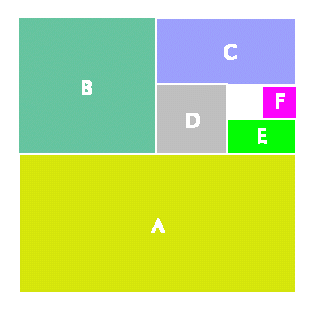
It is sometimes helpful to read a land description "backwards" to identify the larger units first. Locate the township, then the section within the township, and then work out the subdivisions of the section. Equivalent land descriptions for each of these units would be:
- Plot A: South half of section nine, township one south range two east of the Michigan meridian.
- Plot B: Northwest quarter of section nine, township one south range two east of the Michigan meridian.
- Plot C: North half of the northeast quarter of section nine, township one south range two east of the Michigan meridian.
Plot D: Southwest quarter of the northeast quarter of section nine, township one south range two east of the Michigan meridian.- Plot E: South half of the southeast quarter of the northeast quarter of section nine, township one south range two east of the Michigan meridian.
- Plot F: Northeast quarter of the southeast quarter of the northeast quarter of section nine, township one south range two east of the Michigan meridian.
For More Information
If you have a land description in hand (usually from a land patent document or title deed) and want to locate the place on a map, one resource that can help is the Rand McNally Commercial Atlas which can be found in most libraries. The maps in this atlas show the survey meridians and base lines for public land states, and have the township ranges marked. You may have to look closely to find them, though in recent years these elements have been made more clear and the township names are even indicated in many states.
You may also wish to consult the following for more detailed explanations of land surveys and land descriptions in the United States:
Hone, E. Wade. Land & Property Research in the United States. (Salt Lake City, Utah: Ancestry Incorporated, 1997. ISBN 0-916489-68-X.)
Johnson, H. B. Order Upon the Land: The U.S. Rectangular Land Survey and the Upper Mississippi Country. (London: Oxford University Press, 1976.)
Muehrcke, Phillip C. Map Use: Reading, Analysis, and Interpretation. (Madison, Wisc.: JP Publications, 1978. ISBN 0-9602978-1-2.)
Stewart, L. O. Public Land Surveys: History, Instructions, Methods. (Ames, Iowa: Collegiate Press, 1935.)
The text and diagrams on this page are ©1997 by Gary Lee Phillips. Used by permission. Permission is hereby granted for maintainers of other web pages and servers to create links to this page. Educators and non-profit groups are also permitted to print copies of this material for use in seminars and instructional sessions. However, any other rights and privileges, including but not limited to copying, republication, or redistribution for a fee, are reserved by the author and require his explicit permission in writing. Thank you for observing these limitations.
This page was last modified on 4 AUG 2006